Fig. 1 Methane Hydrate Stability as a Function of Climate
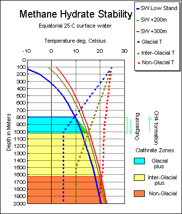 CLIMATES: Red: Non-Glacial; Brown: Inter-Glacial; Blue: Glacial
SOLID LINES: Methane Hydrate stability boundary for specific climate.
Curves calculated from data from Dickens and Quinby-Hunt (1994)
Left of boundary:- Hydrate.
Right of boundary:- Gas.
DOTTED LINES: temperature profiles for specific climate (assume 25C surface water)
Intersection of boundary and temperature profile for specific climate give minimum depth of hydrate formation
Reference Datum is lowest stand of sea level during Glacial times. Assume sea level 200 meters above
Glacial for Interglacial times and 300 meters above Glacial datum for Non-Glacial times.
Green zone shows region of fluctuation between hydrate and gas phase.
o As climate cools hydrate stablility zone rises to shallower depths.
o As climate warms, stablility zone deepens and previously formed hydrate outgasses to the ocean.
Actual temperature and depth values during Interglacial Interval dependant on feed-back mechanism governed by
climatic interaction between carbon sequestering and methane formation/outgassing.